


hors pistes

margotte
User
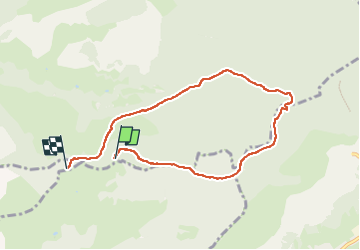

Length
7 km

Max alt
1093 m

Uphill gradient
324 m
Km-Effort
11.4 km

Min alt
778 m

Downhill gradient
350 m
Boucle
No
Creation date :
2024-11-26 14:06:49.36
Updated on :
2024-11-26 19:00:52.634
1h44
Difficulty : Medium

FREE GPS app for hiking
 SityTrail
IGN / Geographical institutes
SityTrail Plus
The world is yours!
About
Trail Walking of 7 km to be discovered at Grand Est, Vosges, Le Ménil. This trail is proposed by margotte.
Photos


Positioning
Country:
France
Region :
Grand Est
Department/Province :
Vosges
Municipality :
Le Ménil
Location:
Unknown
Start:(Dec)
Start:(UTM)
337369 ; 5307476 (32T) N.
Comments